Here is your paragraph on cool season in India!
The cool season starts with the beginning of the withdrawal of southwest monsoon in the middle of September and continues upto November, after which the winter season starts.
The monsoons withdraw from the extreme north-west end of the country in September, from the peninsula by October and from the extreme south-eastern tip by December.
Due to retreat of the monsoon, this season is also called the season of retreating monsoon. Sometimes it is referred to as the post monsoon season.
ADVERTISEMENTS:
A simple comparison of figure 5.18 with 5.20 will show that the south-west monsoons reach north-west India last of all and withdraw from there first of all. Therefore, the duration of the southwest monsoon period is minimum there.
In Punjab, for example, the south-west monsoons reach in the first week of July and withdraw from there in the second week of September, giving only two and a half months of monsoon activity. As against this, the south-west monsoons reach Coromandel Coast in the first week of June and withdraw from there only in the middle of December. Thus the south-west monsoons remain active for more than six months over the Coromandel Coast. Unlike the sudden burst of the advancing monsoons, the withdrawal is rather gradual and takes about three months.
(a) Temperature:
With retreat of the monsoons, the clouds disappear and the sky becomes clear. The day temperature rises a little at the initial stage but soon starts falling rather steeply. In October the day temperature over larger parts of Rajasthan is 37°C. It decreases to 33°C in the peninsula and to 30°C in north-east India.
ADVERTISEMENTS:
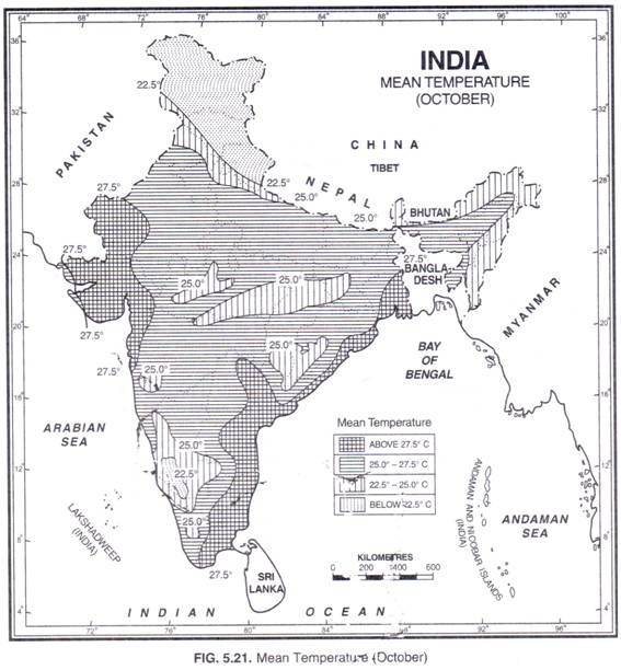
Nights are cool with minimum temperature varying from 20° to 25°C. In the Himalayan region the minimum temperatures reach freezing point. The average temperature in most parts of the country varies from 25° to 30°C. Figure 5.21 shows the distribution of temperature in the month of October. The diurnal range of temperature increases due to lack of cloud cover.
(b) Pressure and Winds:
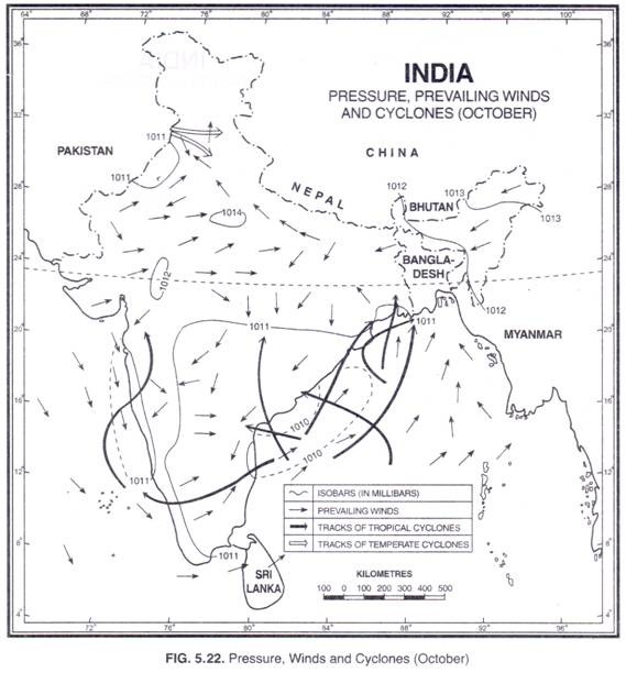
As the monsoons retreat the elongated trough of the low pressure across the Indo Gangetic plains weakens and gradually shifts southward. By October it reaches the Bay of Bengal and moves further southwards as the season advances. The axis of low pressure roughly runs in an east-west direction along 13°N latitude. The surface pressure in most parts of the country varies from 1,010 to 1,012 mb. Consequently the pressure gradient is low.
This is the season when south-west monsoons yield place to the north-east monsoons. Unlike the south-west monsoon, the onset of the north-east monsoon is not clearly defined. In fact, on many occasions, the meteorologists fail to draw a clear demarcation between the withdrawal of the summer monsoon and the onset of winter monsoon over peninsular India. However, the direction of winds over large parts of the country is influenced by the local pressure conditions. (Fig. 5.22).
Cyclones:
ADVERTISEMENTS:
This is the season of the most severe and devastating tropical cyclones originating in the Indian seas especially in the Bay of Bengal. The highest frequency of the cyclones is in the month of October and the first half of November. More cyclones are born in October and then in November and more cyclones originate in the Bay of Bengal than in the Arabian Sea.
In October, the Cyclones of the Bay of Bengal originate between 8°N and 14°N. Initially they move in a west or northwesterly direction, but many of them later recurve and move towards the north-east; about 55 per cent of the Bay storms cross or affect the Indian coast. The area’s most vulnerable to these storms include the coastal belts of Tamil Nadu, Andhra Pradesh, Orissa and West Bengal. Many of the cyclones which strike the eastern coast of India, south of 15°N latitude cross the South Peninsula and enter Arabian Sea.
During this process, they may weaken, but on re-entry over the Arabian Sea they reintensify into cyclonic storms. The storms of Arabian Sea originate between 12°N and 17°N latitudes in October and between 8° N and 13° N latitudes in November. Generally they move away from the coast in a northwesterly direction. But about 25% of them later recurs northeast and strike the Maharashtra or Gujarat coast.
ADVERTISEMENTS:
The cyclones originating in the Bay of Bengal and the Arabian Sea are accompanied by strong surface winds, dense clouds, thundering and heavy downpours. A rainfall of 50 cm in a day is not uncommon, the highest record being around 86 cm in 24 hours at Purnea in Bihar. The heavy rainfall continues for 2-3 days.
In north-west India the western disturbances produce clouding and light rainfall in the otherwise fine weather. The average incidence of western disturbances is 1 to 3, the frequency showing increasing trend with the advance of the season. The precipitation is in the form of snow in higher reaches of Jammu and Kashmir, Himachal Pradesh and in Kumaon Hills.
(c) Precipitation:
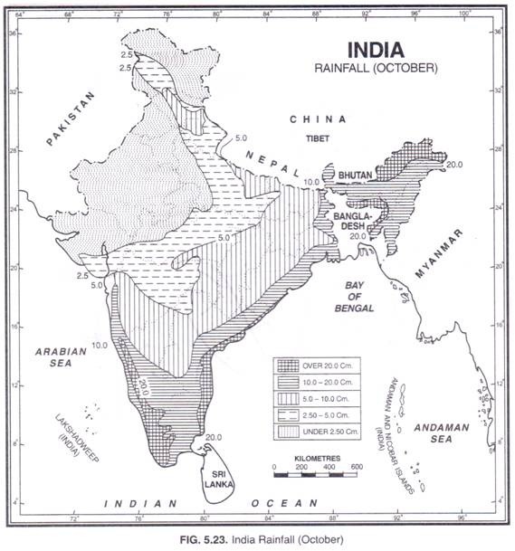
The humidity and cloud cover are much reduced with the retreat of the southwest monsoons and most parts of the country remain without much rainfall. However, October- November is the main rainy season in Tamil Nadu and adjoining areas of Andhra Pradesh to the south of the Krishna delta as well as a secondary rainy period for Kerala.
In fact Kerala has bi-modal pattern of rainfall with main rains in the south-west monsoon season and subsidiary rains in this season. The retreating monsoons absorb moisture while passing over the Bay of Bengal and cause this rainfall.
ADVERTISEMENTS:
According to a study conducted by Krishna Rao and Jagannathan the average rainfall in Tamil Nadu in October and November is 38.25 cm which is about 38.73 per cent of the annual rainfall received here. However, the coastal areas receive about 50% of their annual rainfall during this season.
Annual Rainfall:
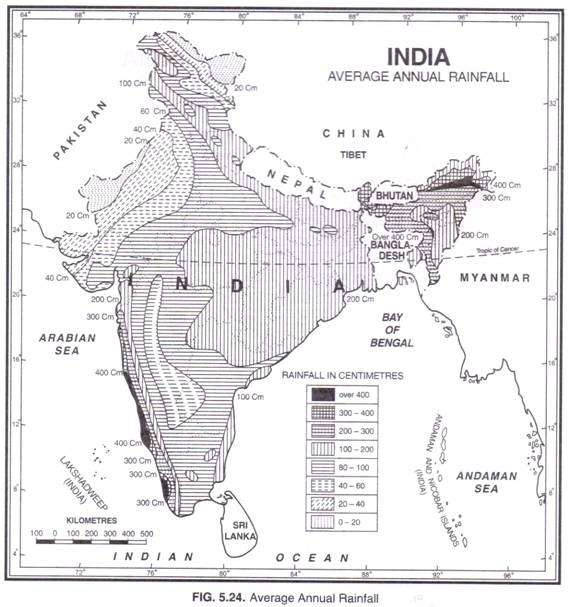
Figure 5.24 shows the distribution of annual rainfall in India. The average annual rainfall of India is about 118 cm which is the highest for a country of such vast dimensions anywhere in the world. But there are large spatial and temporal variations. Large parts of Meghalaya receive about 1,000 cm annual rainfall while on the other end of the scale, some districts in south-west Rajasthan hardly receive annual rainfall of 15 cm In the extreme south, Kanniyakumari and Nellai Kattabomman district get less than 30 cm during the south-west monsoon, while heavy rains of 200 cm or more, lash the nearby Kerala Coast. India can conveniently be divided into following regions depending upon the annual average rainfall received by these regions.
Areas of very high rainfall:
Areas receiving an annual rainfall of 200 cm and above are termed as areas of very high rainfall. These include the west coast from Thiruvananthapuram in the south to Mumbai in the north. The average annual rainfall in this belt is 200-400 cm with localized areas in between receiving 400-800 cm annual rainfall.
Almost the whole of Assam, Nagaland, Meghalaya, Mizoram, Arunachal Pradesh, Sikkim, parts of Manipur, Tripura and north-eastern tip of West Bengal also receive 200 cm or more, with isolated pockets receiving over 400 cm Meghalaya (the abode of clouds) is the wettest part of the country with Mawsynram and Cherrapunji getting 1,221 and 1,102 cm of annual rainfall respectively.
Areas of high rainfall:
These areas receive 100-200 cm annual rainfall. They include eastern slopes of the Western Ghats, major part of the northern plain, Orissa, Madhya Pradesh, Andhra Pradesh and Tanjril Nadu. The isohyet (the line joining places of equal rainfall) of 100 cm rainfall runs southwards from Gujarat coast roughly parallel to the crest of the Western Ghats upto Kanniyakumari.
The rainfall to the west of this line is above 100 cm. To the north, the 100 cm isohyet trends eastward passing over the southern parts of Jammu and Kashmir, Himachal Pradesh and northern Uttar Pradesh.
To the east of Allahabad, it bends to the west passing over Bundelkhand in Uttar Pradesh. Turning west-south-westwards, it runs over western Madhya Pradesh, eastern Maharashtra and northern Andhra.
Areas of low rainfall:
These areas receive 50-100 cm annual rainfall and include large parts of Gujarat, Maharashtra, western Madhya Pradesh, Andhra Pradesh, Karnataka, eastern Rajasthan, Punjab, Haryana and parts of Uttar Pradesh.
Areas of very low rainfall:
These are desert and semi-desert areas receiving less than 50 cm of annual rainfall. They include large areas of western Rajasthan, Kuchchh and most of Ladakh region of Jammu and Kashmir.
Variability of Annual Rainfall:
Rainfall in India does not change with space only but with time also. There are large variations in the total amount of rainfall from year to year. Variability of annual rainfall is computed with the help of the following formula.
Coefficient of Variability (CV) = Standard Deviation/Mean x 100
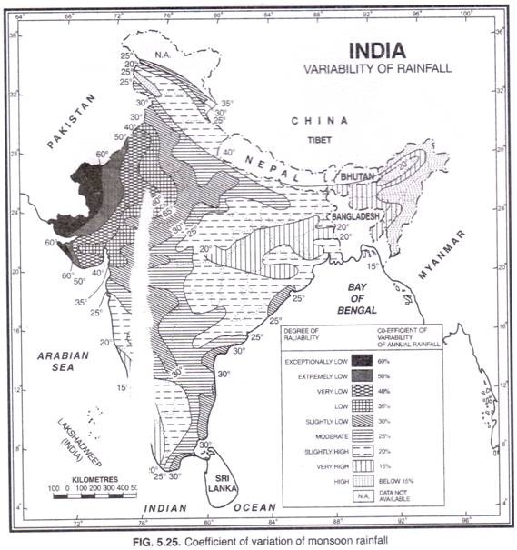
The coefficient of variation indicates the amount of fluctuation in rainfall recorded over a long period of time from the mean values. Figure 5.25 shows the values of the coefficient of variation of monsoon rainfall in India. It generally ranges between 15 and 35 per cent for the country as a whole.
The coefficient of variation in large parts of Rajasthan, Gujarat, and parts of Haryana and Panjab is well over 40 per cent. In extreme western parts of Rajasthan and Gujarat, it exceeds 60%. Incidentally these are the areas which receive minimum rainfall. The other areas of low rainfall and high coefficient of variation are Leh and Ladakh in the north and Rayalaseema in the south.
The areas of low coefficient of variation include the west coast, the sub-Himalayan belt including Sikkim, Arunachal Pradesh, Assam and West Bengal and the north-eastern hilly regions of Nagaland, Manipur and Mizoram. The coefficient of variation in these areas ranges between 15 and 20 per cent. These areas receive heavy annual rainfall of about 200 cm. In general the variability increases from west into the interior of the plateau as well as from Orissa and West Bengal towards the north and north-west.
A major conclusion that can be drawn from the above description is that the variability is highest where the amount of rainfall is the lowest. In other words, the rainfall variability is inverse to total amount of rainfall and reliability of rainfall is inversely proportional to the coefficient of variability.
As such the spatial distribution of rainfall variability has a great bearing on Indian agricultural productivity. Since the areas of high variability are also the areas of low rainfall, they suffer from chronic deficiency of water, frequent droughts and crop failures. The areas with marginal rainfall are the worst sufferers.
However, the study of the coefficient of variation helps us in delineating those parts of the country where long range prediction will be useful. This prediction is not much required in areas of small coefficient of variation. For example, we can safely say that the actual rainfall will be within 10 to 15 per cent of the normal rainfall in Assam and West Bengal.
But in Rajasthan and adjoining areas of north-west India the rainfall may vary by as much as thirty to fifty per cent or even more from the normal. Similarly the variability of the annual rainfall is high in large part of the Indian Peninsula. Evidently these are the areas where advance information about seasonal rainfall plays a crucial role.
