Here is your paragraph on the Aryan rock system of India (Gondwana System)!
The Aryan System comprises the rock formations ranging from the Upper Carboniferous to Recent.
They are fairly preserved in the Peninsular India and are found in a perfect sequence in the Himalayan region along the entire northern border.
The Gondwana System derives its name from the Kingdom of the Gonds, the most primitive people living in Andhra Pradesh. It has relevance with the Gond region of Madhya Pradesh also where these rocks were first discovered. The Gondwanas consist of sandstones with some shales and clays.
ADVERTISEMENTS:
They are of continental origin, fluviatile and lacustrine deposits laid down in geosynclinal troughs on ancient plateau surface. As the sediments accumulated, the loaded troughs subsided which led to thick deposits of fresh water and sub-aerial sediments into which were embedded the terrestrial plants and animals.
These flat sedimentary strata, some 6,000 m thick, were laid down from the start of the Permian period some 250 million years ago. The system shows several climatic changes during its deposition.
ADVERTISEMENTS:
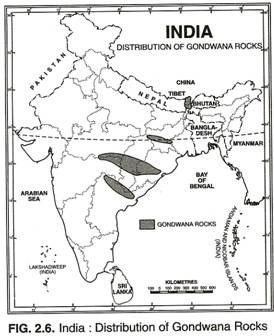
The main areas of Gondwana rocks in the Peninsula are along the Damodar Valley in Jharkhand, along the Mahanadi river valley in Chhattisgarh and Orissa, in the southern part of Madhya Pradesh and a series of troughs along the Godavari from Nagpur to the delta (Fig. 2.6).
In the extra-peninsular region these rocks are found in Kashmir, Darjeeling and Sikkim. Here they are so much deformed that they have lost their original identity and are entirely different from the peninsular rocks.
Economically, the Gondwana rocks are the most important in India containing about 98 per cent of her coal reserves. They have rich deposits of iron ore, copper, uranium and antimony. Sandstones, slates and conglomerates are used as building materials.
The Triassic System meaning three fold (280-225 million years) is almost unknown in the Peninsula but are found over extensive areas from Hazara to Nepal. Impressive sections of the system are exposed on the south flank of the Great Himalaya range from Kashmir to Byans in Eastern Kumaon.
The trias are generally divided into lower, middle and upper divisions. The Lower Trias is over 100 m thick in Kashmir, 50 m in Byans and only 12 m in Spiti. The Middle Trias is 275 m thick in Kashmir. The Upper Trias of Kashmir is 1200-1800 m thick well bedded limestones. In the Spiti both these stages are represented by about 1,000 m thick dominantly calcareous strata.
ADVERTISEMENTS:
The Jurassic System, after Jura Mountains on the borders of France and Switzerland (180 million years) overlies the Triassic, covering wide areas in Tibet, South Ladakh, Spiti, Nepal and Bhutan, where limestone occurs to a depth of 600-900 m.
The marine transgression in the latter part of the Jurassic gave rise to thick series of shallow water deposits in Rajasthan and in Kachchh. There is 190 km long and 64 km wide area in Kuchchh which is covered by rocks of the Jurassic system. Coral limestone, politic limestone, sandstone, conglomerates and shales occur in Kuchchh.
The Jaisalmer area of Rajasthan also has some Jurassic rocks. Another transgression on the east coast of the Peninsula between Guntur and Rajahmundry has resulted in the development of marine Upper Jurassic strata interbedded with the upper Gondwana formation.
The Cretaceous System, from Creta, the Latin name for chalk (135-70 million years), is one of the best developed marine systems of India showing a variety of faces and represented by a wide variety of rocks, deposited in the land, sea estuaries and lakes. No other system is as widely distributed in India as the Cretaceous System is, both in the Peninsular and the Extra-peninsular parts.
ADVERTISEMENTS:
The Cretaceous rocks of the Spiti area include sandstones, quartzites, limestones and shales. In the Kumoun region, the important rocks are sandstones and shales. Cretaceous limestones are also found in Rupshu and Burzil areas of Kashmir. The plateau of Meghalaya has sandstones. The upper Cretaceous system occurs in the Pondicherry-Tiruchchirapalli belt.
Some detached outcrops of marine Cretaceous, known as Bagh Beds in Gwalior are found along the Narmada Valley where they underlie the Deccan Trap. In the Central parts of the Peninsula occur estuarine and lacustrine deposits called the Lemetas.
The Deccan Trap:
From the end of the Cretaceous till the beginning of the Eocene, stupendous volcanic outburst overwhelmed a vast area of the Peninsular India, like the one which is seldom known anywhere else in the world geological history. A vast area of about ten lakh sq km was flooded by the outpourings of extremely mobile basalt lava from fissures and cracks covering fully the pre-existing topography.
ADVERTISEMENTS:
These volcanic deposits have flat top and steep sides so that they appear as gigantic steps from a distance, and therefore called trap, the name derived from the Swedish word meaning a ‘stair’ or ‘step’. However, Spate feels that the term Deccan Trap is used in old literature and he prefers to use the term ‘Deccan Lava’ instead.
The individual lava flows that make up the Deccan Trap plateau vary greatly from a fraction of a metre to 36 metres in thickness. The hills formed by them are in some places over 1200 metre high. It is estimated that the molten rock of the order of 6.5 million cubic metres, exceeding the bulk of the entire Himalaya, was poured out from the interior of the earth to form this volcanic plateau over 1800 m in height.
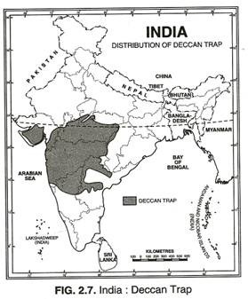
The process of denudation over a long period has reduced the Deccan Trap to almost half of its original size and the present Deccan Trap covers about 5 lakh sq km mainly in parts of Kuchchh, Saurashtra, Maharashtra, the Malwa plateau and northern Karnataka (Fig. 2.7).
Parts of Andhra, Tamilnadu, Jharkhand and Uttar Pradesh also have some outliers of the Deccan Trap. Thickness of the Deccan Traps is not uniform everywhere. It is as much as 3,000 metres along the coast of Mumbai which is reduced to 600-800 metres towards the southern limit, 800 metres in Kuchchh and only 150 metres at Amarkantak near its eastern limit. The Deccan Trap has been divided into following groups:
(a) The Upper Trap, found in Maharashtra and Saurashtra has numerous inter-trappean beds and layers of volcanic ash and has an average thickness of about 450 m.
(b) The Middle Trap is about 1200 m thick and is spread over Central India and Malwa. It has numerous ash-beds in the upper portion and is practically devoid of inter-trappeans.
(c) The Lower Trap is only 150 m thick with inter trappean beds but rare ash beds. It is found in Central India and Tamil Nadu.
Basalt is the main rock but dolorite, rhyolite, gabro and many other rocks are also found. These rocks are a great source of quartz, agate, calcite, building stones and road building material. The weathering of these rocks for a long time has given birth to black cotton soil known as ‘regur’.
The Tertiary System:
The rocks of the Tertiary System were formed from Eocene to Pliocene about 60 to 7 million years ago. The tertiary is the most significant period in India’s geological history because the Himalayas were born and India’s present form came into being in this period. The Tertiary has been called the Age of the Mammals because of the abundance of the fossil remains of these animals in the deposits of this period. The Tertiary System is generally divided into the following three systems.
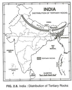
(a) The Eocene System (60 million years ago) is mainly found in Jammu and Kashmir, Himachal Pradesh, Rajasthan, Gujarat and in the north-eastern part of India. The Eocene belt of Jammu goes upto Shimla and further east upto Mussoorie.
Such deposits also occur in the southern flank of the Pir Panjal. In Rajasthan, the lignite deposits belong to the Eocene System. The Kuchchh, Surat and Broach areas of Gujarat have deposits of the Eocene System.
In the north eastern parts of the country, the Eocene is represented by limestones and coal-bearing sandstones in Jaintia series in the southern and eastern parts of the Meghalaya plateau. The Barail series has a wide distribution in Surma Valley and in the Naga Hills. The Tertiary coal deposits of Upper Assam are worth noting. Some Eocene deposits have recently been noticed in Pondicherry.
(b) Oligocene and Lower Miocene System (40-25 million years) is very poorly developed in India. It is estimated that during a part of this period the Tertiary outcrops suffered considerable denudation which resulted in the removal of rocks belonging to this system. Rocks of the Oligocene age are found in the greater part of the Barail series of Assam where they are overlain with a marked unconformity by Lower Miocene rocks.
Unlike the Oligocene, the Miocene system is fully developed in India and is found in all the Tertiary areas of the extra-Peninsula. The outcrop of the Murree series in Jammu hills, forming a belt 25-40 km wide from the Indus to the Chenab, narrows towards the east and merges into the typical Dagshai-Kasauli band (Sirmur series) is of Shimla area.
The thickness of the deposits in Dagshai- Kasauli band is about 2600 m and is dominated by red clay and sandstone. No major fossils are seen in Dagshai and Kasauli group. The coal measures of Assam, belonging to the Barail series are overlain by the Surma series.
It is composed of sandstones and sandy shales, mudstones and conglomerates. The deposits of Garo Hills have large number of marine fossils. Besides some rocks of Kuchchh in Gujarat, Mayurbhanj in Orissa, Durgapur in West Bengal, and Kollam in Kerala also belong to this group.
The Shiwalik System—Middle Miocene to Lower Pleistocene (14 to 0.2 million years ago) takes its name from Shiwalik hills between rivers Ganga and Yamuna, where they were first known to science. It is from here the first palaeontological treasures were obtained which have made this system extremely famous with the geologists all over the world.
The Shiwalik strata are found all along the length of the Shiwalik hills. Sandstones, grits, conglomerates, clays, and silts comprise the rocks of this system. They have been deposited in lagoons and fresh water lakes by the rivers of that time upto a thickness of about 5000 m.
The great bulk of the Shiwalik formation is nonfossiliferous, but in certain areas some formations are highly fossiliferous. The fauna records the sedimentation from Middle Miocene to Lower Pleistocene and has yielded a variety of fossils showing wide range of environment—from humid forest conditions to aridity. The mammalian fossils were first discovered from the Shiwaliks near Haridwar in 1839.
Table 2.1 Division of Shiwalik Strata:
| Upper Shiwaliks 1800- 2750 m | Boulder Conglomerate beds, Sandstones, thick earthy clays. Richly fossiliferous in Shiwalik hills | Lower Pleistocene to Upper and Lower Pliocene |
| Middle Shiwaliks 1800- 2500 m | Gravels, sandstones, shales and clays | Upper to Middle Miocene |
| Lower Shiwaliks 1200-1500 m | Bright red shales and Sandstones | Middle Miocene |
The Shiwalik strata are divided into the following three sections, the passage from one into the other division being quite gradual and transitional.
In Assam the Shiwalik system is almost equivalent to the Tipam, Dupi Tila and Dihing series. In the southern part of Assam, the lower part of the Tipam series consists of coarse ferruginous sandstones and sandy shales, and has some marine fossils.
Above the Tipam series lies the Dupi Tila series which consists of sandstone and conglomerates. Its lower beds contain the oil fields of Lakhimpur and Digboi. The Dihing beds overlie the Dupi Tila and correspond to the Upper Shiwaliks.
The Shiwalik rocks are also found in Kuchchh and Saurashtra areas of Gujarat. Highly fossiliferous beds have been struck in a well at Karikal on the Thanjavur coast (Tamil Nadu). In Mayurbhanj area of Orissa there are rocks of Miocene age. Some rocks of Middle Miocene and Lower Pleistocene age are seen in Varkala (Kerala) as well as in the sandstones of Cuddalore and Rajahmundry.
The Shiwalik system is famous for its oil resources, lignite, bauxite and clays of different varieties.
The Pleistocene and Recent (Quaternary) is a brief period of nearly one million years and is said to have just begun. It has two divisions without a clear-cut boundary between them. The older is the Pleistocene which is marked by cold climate and glaciation.
The younger division is called Recent. It started about 12,000 years ago since the withdrawal of the last glaciation. The Pleistocene age has been marked by several advances and retreats of the glaciers. This age is divided into four glacial and three inter-glacial periods by de Terra and Paterson. During the glacial periods, sea level was lowered by about 100 metres than it is now and this resulted in much larger extension of land.
The Himalayan glaciers were much larger during the glacial period than their present size. They have left indelible impression on the Himalayan topography. The First Glacial and Inter-glacial periods belong to the lower Pleistocene in Kashmir. The Second Glacial and Inter-glacial periods embrace Middle Pleistocene.
Heavy deposition of sediment consisting of boulder fans and thick fluvo-glacial material took place in this period. The Karewas of Kashmir are supposed to be of the second interglacial period. The flat-topped terraces of the Kashmir valley and on the flanks of the Pir Panjal consisting of clays, sands, silts together with lenticles of conglomerate from old deltaic fans are known as Karewas in Kashmiri language.
The alluvial deposits of the Narmada are also of the same period. The Upper Pleistocene includes the Third and the Fourth glaciations and the intervening Third Inter- Glacial period. Pir Panjal experienced uplift during the First and the Third Glacial periods, and the terrace deposits of Kashmir occurred at the end of the Fourth Glaciation.
The fossiferous clays, sands and gravels of the Upper Satluj and the alluvial deposits in the valleys of Tapi, Godavari and Krishna are also of the Pleistocene age.
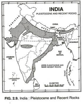
The most important, extensive and recent deposits in India are the Indo-Gangetic alluviums filling the great depression between the foot of the Himalayas and the northern edge of the Peninsula. The older alluvium called bhangar is of the Middle or Upper Pleistocene age. The newer alluvium occupies the lower areas of the river valleys prone to annual floods is called khadar and belongs to the Upper Pleistocene age.


