4 Major Disputes between India and Pakistan are 1. The Rann of Kachchh Dispute, 2. The Kashmir Problem, 3.The Siachin Glacier Dispute, 4. Sir Creek !
Consequently boundary has been marred by a number of disputes and hostile activities from both the countries ever since it came into being.
Following disputes are worth mentioning.
(i) The Rann of Kachchh Dispute:
Rann of Kachchh boundary was well defined according to Radcliffe award but Pakistan advocated that it was not properly delineated. That country argued that the Rann was not a marsh but a land-locked sea or lake and as such it should be equally divided between India and Pakistan.
ADVERTISEMENTS:
India countered Pakistani claim by presenting documentary proof that the Rann was a marsh which always remained a part of the Kachchh state. As this state merged with India after independence, the entire Rann of Kachchh should be given to India.
Pakistan claimed about 9,065 sq km out of a total area of 20,720 sq km of the Rann of Kachchh. During the 1965 Indo-Pakistan war, the Pakistan troops invaded this area and reached inside the Indian Territory.
ADVERTISEMENTS:
The matter was referred to a boundary tribunal constituted by the International Court of Justice which awarded 906.5 sq km area of the Kachchh to Pakistan. After a number of protests and representations both India and Pakistan accepted the award and the demarcation of the boundary was completed in June 1969.
(ii) The Kashmir Problem:
The former princely state (more precisely the state of Jammu and Kashmir), is undoubtedly the most complex and serious problem between India and Pakistan and is major stumbling block in normalising the relations between the two countries.
The Kashmir problem has led to bloody wars between the two countries in 1948, 1965, 1971 and more recently in 1999. Besides there had been skirmishes adding to bitterness between the two countries. Both countries have large political, economic and strategic stakes in Kashmir and this state has become a symbol of national prestige and honour for either of the two countries.
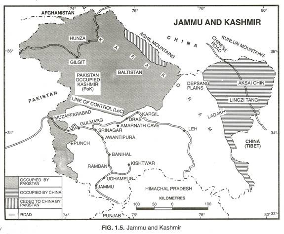
With an area of 2,22,236 sq km Jammu and Kashmir is the sixth largest state of India and represents heterogametic character with regard to geographic, economic, cultural and linguistic elements. The whole state of Jammu and Kashmir can be treated as conglomeration of six distinctive regions.
These regions (excepting for Hunza-Gilgit and Nagar) were brought as a united political unit by Maharaja Gulab Singh, who entered into a subsidiary alliance with the British within the Indian empire in 1849. The first is the beautiful Kashmir Valley.
It is the most important centre of tourist attraction and politically the seat of central authority. Until recent time, it was accessible from India by a single road. This road remained snowbound until the introduction of snowplows in 1948. A few roads connect it with Pakistan.
ADVERTISEMENTS:
The nucleus of dispute in this valley is its overwhelmingly Muslim population. The minority of Kashmiri Brahmans have been holding high positions of economic, social and political significance, whereas the Muslim peasantry remained very poor.
The second is the Jammu region which lies in the southern part of the state. It covers only one-seventh of the total area of the state and is predominantly a Hindu region. More than half of the population of this region consists of Hindus. Jammu is the winter capital of the state and home of state’s former rulers—the Dogra Rajputs.
The Third region is Gilgit. It lies in the northern part of the state. This region is marked by high mountains and is almost entirely inhabited by Muslims. Previously it used to be reached from Srinagar by crossing high mountains, plateaus and glaciers. Now it is well linked to Pakistan through Karakoram highway built by China-Pakistan in 1970.
The fourth region is that of Baltistan which lies in the extreme northern part of the state. Like Gilgit, it contains high mountains and is not easily accessible. It is reached by road along the Indus River in Pakistan. It is an overwhelmingly Muslim area.
ADVERTISEMENTS:
The fifth region is that of Punch which lies to the north of the Jammu region and in the west of the Kashmir valley. It is near the Pakistan border and is inhabited by Muslims. Pakistan has easy access to this region.
The sixth is the Ladakh region which is also known as ‘Little Tibet’. It lies in eastern part of the state and covers about one-third territory of the state. It is a vast, barren, high plateau which resembles Tibet in many respects.
As mentioned earlier, the state was ruled by a Hindu whereas about 77 per cent of the population of the consisted of Muslims before partition of the country. It is an extremely important state from the strategic point of view because of its contiguity to India, Pakistan, China and Afghanistan and proximity to Tajikistan (formerly a part of the U.S.S.R.).
The state was sought by Pakistan on the basis of its Muslim majority status. Moreover, major rivers of Pakistan namely Ravi, Chenab, Jhelum and Indus flow through Kashmir. Unlike most of the rulers of princely states who had acceded to either India or Pakistan before August 15, 1947, ruler of Kashmir did not make up his mind.
ADVERTISEMENTS:
The Maharaja thought that any decision to accede to India or Pakistan may spark off chain reactions and disturb the peace of the state. Pakistan cut off the communications and stopped the supply of essentials to coerce Kashmir to accede to Pakistan. On October 22, 1947, fully armed tribesmen, supported by Pakistani armed forces, invaded Kashmir.
They indulged in large scale killing of Hindus and Muslims and committed large scale looting and arson. This forced the ruler to make a desperate appeal to the Indian government for military help. India promised to help the ruler but only after he decided to accede to the Indian Union.
The ruler agreed to this condition and the instrument of accession of Kashmir was signed by Maharaja Hari Singh on October 26, 1947. The accession was accepted by the Governor General of India on October 27, 1947. Thus, Kashmir became legally and constitutionally an integral part of the Indian Union.
Pakistan described the Maharaja’s accession to India as based upon “fraud, deceit and Violence”, and maintained that it was totally against the wishes of its long oppressed Muslim subject. Soon after, Pakistan rushed its own troops to support the invading tribesmen. India quickly moved its troops to halt the invaders and Indo-Pakistan war broke out in 1948.
India could have done much better, had it flushed out the invaders from the entire state. Instead, India took the case of aggression from Pakistan to the United Nations which immediately appointed a commission to investigate the dispute.
The United Nations commission on India and Pakistan (UNCIP) proposed a plebiscite to ascertain the wishes of the people of the state. It also called on India and Pakistan to agree on a cease-fire line. A cease-fire line was delimited with areas of high altitude left un-delimited. The line was accepted by both India and Pakistan on January 1, 1949.
The cease-fire line left India in possession of two-thirds of the state including the Kashmir valley, lying south-east of the line, and one-third area in the north and west of the line remained under Pakistan’s control.
The area is administered through the so-called Azad Kashmir government. The cease-fire line (adjusted under Shimla Agreement as Line of Actual Control) has crystallized into de facto boundary between areas controlled by India and Pakistan respectively.
Right from the beginning Pakistan has been insisting on plebiscite in the entire state in the hope that such an exercise will give clear mandate in its favour. That country argues that plebiscite has been recommended by the United Nations. India, on the other hand, held the position that Kashmir’s accession had given India sovereignty over Kashmir.
Initially agreeing to the proposal of plebiscite, India rejected it on the ground that Pakistan had not withdrawn its invading forces from Kashmir. This condition was stipulated by the United Nation resolution, but had never been realised on the ground. India has been regularly stressing upon the illegality of Pakistani support of the raiders and the Azad Kashmir government.
Pakistan blames India for failing to withdraw its forces from the Indian- controlled territory, and for supporting a regime prejudicial to holding of a plebiscite. Since then the issue has been listing in the U.N. Security Council and the Cease Fire line or Line of Actual Control divides Kashmir between Indian and Pakistani occupied areas.
Ever since Kashmir’s accession to India, the Kashmir government in Srinagar has maintained a close relationship with the Indian Union, and in 1952, negotiated a pact which has given it a special status within India. In 1956, arrangements were made for establishing an elected constituent assembly for Kashmir which voted to make it a regular state within India. Since then, India has treated Kashmir as a constituent unit of the country and the state is no longer open to a plebiscite.
Two major considerations have guided India’s policy about Kashmir problem. First, India is secular state and surrender of Kashmir to Pakistan on religious grounds would amount to denial of the nation’s essential principles.
Second, the strategic location of Kashmir is of great importance to India. China’s occupation of Tibet and part of Ladakh and building a road through Aksai Chin to serve Tibet and Sinkiang, and full scale aggression on India in 1962 further lent urgency to the strategic aspect of Kashmir’s location.
China helped Pakistan in building a new road across its occupied area to Sinkiang and Pakistan, in turn, ceded a large territory of 5,180 sq km to China.
This move by Pakistan has been termed as illegal; because India claimed that the entire state including the territory controlled by Pakistan, annexed by China and ceded by Pakistan to China belonged to India. Thus, out of a total area of 2, 22,236, a territory of 78,114 sq km is under illegal occupation of Pakistan, and 5,180 sq km illegally handed over by Pakistan to China and 37,555 sq km under illegal occupation of China in Ladakh district.
Pakistan has so far made four abortive attempts to conquer Kashmir. Its forces had to trace back in 1947-48 war when Kashmir was legally acceded to India. Pakistan again invaded in 1965 and it was badly mauled by the Indian forces.
The 1971 India-Pakistan conflict led to the liberation of East Pakistan and emergence of a new country by the name of Bangladesh. This left Pakistan a truncated country and added much to already increasing bitterness between India and Pakistan.
In 1999, Pakistani troops stealthily occupied certain positions in the Kargil sector for which India had to use strong force. Unable to beat India in regular warfare, its forces are launching proxy war in Kashmir and sending foreign mercenaries and terrorists to disturb law and order in and incite communal tension in the state.
Due to its link with Islamic terrorist organisations and ISI, Pakistan has become the hot- bad of international terrorism and is posing a serious threat to world peace. Even after about six decades of Kashmir’s accession to India, there seems no sign of resolving the Kashmir problem as both sides stick to their respective positions.
India is taking no chance to safeguard the integrity and sovereignty of the country, particularly of Jammu and Kashmir. There are an estimated 1,00,000 Indian troops ranged along 188 km International Border, the 788 km Line of Control (LoC) and 150 km Actual Ground Position Line (AGPL).
(iii) The Siachin Glacier Dispute:
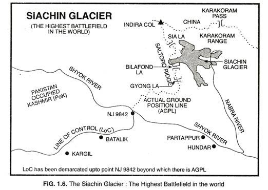
Siachin glacier is about 75 km long and 2 to 8 km wide. This glacier has the distinction of being the largest glacier outside the Polar or sub-Polar regions. It covers an area of about 450 sq km at an altitude of about 5,800 metre above sea level in Ladakh region near Karakoram Range.
The Karakoram highway between China and Pakistan is very close which enhances its strategic value. India occupies about two-third area of the glacier in its south-eastern part. Here Nubra river emerges from Karakoram glacier and meets the Shyok river which is a tributary of the Indus river. Indian troops use the Nubra valley to reach the glacier. The glacier has four passes. Of these Gasherbrum, Saltoro and Vilafondala are in India and Gyongla is in Pakistan.
It is worth mentioning that LoC demarcated in 1972 after the Shimla agreement stopped dead at the grid reference NJ. 9842, with no indication as to how it would run along the 70-odd km left to the Chinese border in the north.
While Pakistan decided to extend this line eastward to Karakoram Pass, thus claiming an area two-thirds the size of Sikkim, India’s decision was to go by the wording of 1949 Karachi agreement that was superseded by LoC of 1972 which spoke of line “thence northwards joining the glaciers”. Further, India wants Pakistan to officially recognise the Actual Ground Position Line (AGPL) begin NJ. 9892 grid point as a pre-requisite to de-militarisation of the Siachin glacier.
Pakistani troops established an observation post on Saltoro range. To counter this, India launched Operation Meghdoot on April 13, 1984. Since then both the countries are maintaining troops in this inhospitable environment at a very high altitude. A number of skirmishes have taken place making it the highest battlefield in the world (Fig. 1.6).
Sending men and material in such an area is a very expensive affair. On an average India spends about Rs. 4 crore per day for maintaining troops in this hostile area. Pakistan also spends about Rs. 1 crore for the same purpose. Casualties on both sides of the border are also very high.
Even in normal circumstances, Indian troops suffer one casualty every second day while Pakistani troops suffer one casualty every fourth day. Besides there are psychological disorders, frostbite, high altitude pulmonary and cerebral edema and snow blindness. Such heavy losses can be avoided if both the countries start living in peace as friendly neighbouring countries.
(iv) Sir Creek:
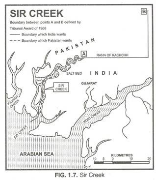
Sir Creek forms the boundary between Gujarat state of India and Sind Province of Pakistan. This creek is extremely rich in marine life and both the countries desire to include it in their respective territories.
While India claims that the middle point of Sir Creek should be demarcated as the international boundary, Pakistan wants the eastern bank of the Creek as the border between India and Pakistan (Fig. 1.7). As such Sir Creek has become a contentious issue between the two countries as Pakistan has been claiming a 40 km region inside India’s territory.
Pakistan has responded positively to the goodwill gesture initiated by India since early 2004 to ease tension on the border. This can lead to friendly relations between the two countries if the concerned countries take necessary positive steps for normalisation of relations.
Some of the steps taken/proposed are:
(i) Srinagar-Muzaffrabad has survice.
(ii) Kargil-Skardu bus link and routes into Poonch-Rajouri sector.
(iii) Amritsar-Lahore bus and rail link.
(iv) Meeting points for divided families across LoC at Poonch, Mendhar,
(v) Suchetgarh, Uri, Tangdar and Kargil.
(vi) Rail link between Munnabao (Rajasthan) and Khokrapar (Sind).
(vii) Link between Ferozpur and Sahiwal.
(viii) Trade across the LoC/border.
(ix) Mechanisms to permit two-way religious pilgrims.
(x) Promotion of cultural interaction and cooperation.
(xi) Joint efforts to promote tourism.


