Here is your paragraph on the origin of Himalayas!
Several scholars have expressed their views regarding the origin of the Himalayas. Prominent among them are O.H.K. Spate, D.N. Wadia, M.S. Krishnan, S. Burrard, E.H. Pasco, G.E. Pilgrim, de Terra, T.T. Paterson, T. Hagen, Auden, A. Heim and A. Gansser, Wagner and a host of others.
There is almost a complete unanimity that the Himalayan Mountains have come out of a great geosynchine called the Tethys Sea and that the uplift has taken place in different phases. But divergent views have been expressed regarding the process and time of uplift as well as the forces responsible for uplift on such a vast scale. The consensus which has emerged from the views of different scholars is reproduced as under:
About 120 million years ago, the arrangement of continents and oceans was quite different from what it is today. There was a super continent known as Pangaea. Its northern part consisted of the present North America and Eurasia (Europe and Asia) which was called Laurasia or Angaraland.
ADVERTISEMENTS:
The southern part of Pangaea consisted of South America, Africa, South India, Australia and Antarctica. This landmass was called Gondwanaland. In between Laurasia and Gondwanaland, there was a long, narrow and shallow sea known as the Tethys Sea. Sediments were brought by rivers from these landmasses and deposited in the bed of this sea.
These sediments were subjected to powerful compression, either because of the southward movement of the Angaraland or due to the northward movement of the Gondwanaland. Majority of the scientists believe that it is the northward movement of the Gondwanaland which caused compression in the sediments at the floor of the Tethys Sea.
ADVERTISEMENTS:
In any case, whether Angaraland moved southwards or Gondwanaland moved northwards or both moved towards each other, the net result would be the same; the sediment in the Tethys Sea was squeezed and crushed, and a series of folds were formed one behind the other giving birth to the highest relief features on the earth—the Himalayas.
The curved shape of the Himalayas convex to the south is attributed to the maximum push offered at two ends of the Indian Peninsula during its northward drift. In the northwest it was done by the Aravalis and in the north-east by the Assam ranges, both acting as two extended arms pushing out the extremities, while the central area sagged giving the arcuate shape to the Himalayas. Recent studies have shown that India is moving northwards at the rate of about five cm per year and crashing into rest of the Asia, buckling the Himalayas between Angaraland and Gondwanaland.
It is important to note that the Himalayas do not comprise a single range but a series of at least three ranges running more or less parallel to one another. Therefore, the Himalayas are supposed to have emerged out of the Himalayan Geosyncline i.e. the Tethys Sea in three different phase’s о lowing one after the other.
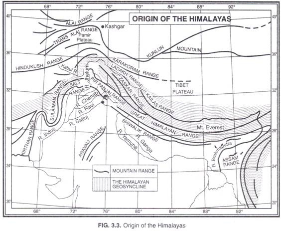
The first phase commenced about 120 million years ago, when the Great Himalayas were formed. Some geologists are of the opinion that the formation of the Great Himalayas was completed about 70 million years ago. The second phase took place about 25 to 30 million years ago when the Middle Himalayas were formed. The Shiwaliks were formed in the last phase of the Himalayan orogeny—say about two million to twenty million years ago (Fig. 3.3).
The diastrophic movements which helped in the formation of the Himalayas started in the late Cretaceous times and continued through the Eocene, Middle Miocene, Pliocene to the lower Pliocene and finally into the upper Pleistocene to sub-Recent times.
There are evidences to show that the process of uplift of the Himalayas is not yet complete and they are still rising. The heights of various places as determined by trigonometrical methods indicate that the Himalayas continue to rise till date.
ADVERTISEMENTS:
According to the estimates made by Godwin Austen, the average elevation of the Himalayas was 2,440 m above the sea level about a million years ago which has now risen to 3,050 m. The Mahabharat range is still in a state of rigorous uplift. Following evidences are cited to prove that the Himalayas are still rising:
(i) Some of the fossil formations found in the Shiwalik hills are also available in the Tibet plateau.
It indicates that the past climate of the Tibet plateau was somewhat similar to the climate of the Shiwalik hills and that the elevation of Tibet plateau was almost the same as that of the present Shiwalik hills and the plateau has since risen to its present elevation.
(ii) Desiccation of lakes of Tibet has been observed within the recent or even in historical times. Surrounding these lakes, the sand and gravel terraces at higher levels, sometimes 60-100 metres above the present water level, are seen which prove that the water stood at a much higher level till recent times. This could be possible only in the event of uplift of the region.
ADVERTISEMENTS:
(iii) The frequent occurrence of earthquakes in the Himalayan region shows that the Himalayas have not yet attained the isostatic equilibrium and they still continue to rise further.
(iv) The Himalayan rivers are still in their youthful stage and have been rejuvenated in recent times. This is another proof of rising trend in the Himalayas. Terraces found at the valley sides suggest rejuvenation of the valley region due to uplift.
The present rate of uplift of the Himalayas has been calculated at 5 to 10 cm per year.
